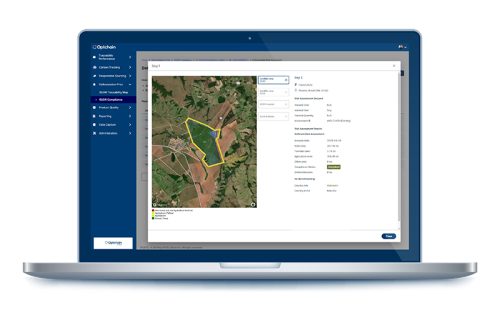
One critical aspect of EUDR compliance is the accurate collection and reporting of geolocation data. This data is necessary for tracing the origin of commodities and ensuring they are not linked to deforestation. However, the geolocation requirement poses challenges for businesses, particularly those with complex supply chains. In this article, we will discuss these challenges and offer best practices for overcoming them, including how technology platforms like Optchain can simplify compliance.
THE CHALLENGE OF EUDR GEOLOCATION DATA COLLECTION
Geolocation data is the backbone of the EUDR’s traceability requirements. Businesses must provide coordinates for the plots of land where commodities are produced, ensuring that these locations are not linked to deforestation after December 31, 2020. However, collecting and standardizing this data across diverse and often global supply chains is far from straightforward. Here are some of the challenges to keep in mind:
- Diverse Geolocation Formats: In a typical supply chain, geolocation data might be captured in various formats, including KML, SHP, and other GIS file types. These formats vary in their complexity and compatibility with different systems, creating challenges for businesses that need to consolidate this data into the required GeoJSON format.
- Field Data Collection: For many operators, especially those working with smallholder farmers or in remote regions, collecting geolocation data directly from the field is a significant challenge. Many of these areas lack the necessary infrastructure, such as mobile network coverage, to support data collection.
- Specific Requirements for Plot Sizes: The EUDR has specific requirements based on the size of the plots of land. For plots over 4 hectares, geolocation data must be provided using polygons, which involve detailed latitude and longitude points to describe the perimeter. For smaller plots or establishments where cattle are kept, a single point of latitude and longitude may suffice. Understanding and adhering to these distinctions is essential for compliance.
BEST PRACTICES FOR MANAGING EUDR GEOLOCATION DATA
The EUDR’s geolocation requirements require a combination of strategic planning and the right technological tools. Below are key practices that can help businesses ensure compliance and improve their geolocation data management processes.
- Standardize and Convert Geolocation Formats: Given the diversity of geolocation data formats across supply chains, it’s important to use platforms that can standardize and convert different formats into GeoJSON. Optchain, for example, supports various GIS formats such as KML, SHP, and others, converting them into the required GeoJSON format automatically.
- Implement Data Verification Processes: To ensure compliance, businesses should implement a verification process for their geolocation data. This can include cross-referencing the collected data with satellite imagery, using third-party verification services, or employing automated tools that check for inconsistencies and errors in the data before it is submitted to the EU Portal.
- Continuous Monitoring and Updates: The geolocation data submitted under the EUDR must be kept up to date. This means that businesses need to establish processes for continuously monitoring their supply chains and updating their geolocation data as necessary. Any changes in land use, production practices, or supply chain configurations must be reflected in the data to avoid non-compliance.
FREQUENTLY ASKED QUESTIONS ABOUT EUDR GEOLOCATION
- What formats can geolocation data be collected in, and how should it be submitted?
Geolocation data can be collected in various formats, including GeoJSON, KML, and SHP files. However, for EUDR compliance, this data must be converted to the GeoJSON format before being submitted to the EU Portal. Platforms like Optchain can assist in this conversion process. - How should geolocation data be provided for different plot sizes?
For plots of land larger than 4 hectares, geolocation data must be provided using polygons, which outline the perimeter of the land with precise latitude and longitude points. For smaller plots or for establishments where cattle are kept, a single geolocation point may be enough. - Can a single polygon cover multiple plots of land?
No, each polygon should represent a single plot of land. A polygon cannot be used to trace the perimeter of a random land area that includes multiple plots. If a commodity is produced on multiple plots, each plot must have its own polygon in the due diligence statement. - What happens if geolocation data cannot be collected from all plots of land?
If an operator cannot collect geolocation data for all plots contributing to a relevant product, they are not allowed to place that product on the EU market or export it. - Are there different requirements for different types of commodities?
Yes, in the case of cattle. While most commodities require polygon-based geolocation for large plots, cattle establishments can be described with a single point.

EUDR GEOLOCATION – WHAT TO CONCLUDE
Technology plays a critical role in helping businesses overcome the challenges of EUDR compliance. Platforms like Optchain offer solutions that support businesses throughout the entire process, from data collection to Due Diligence Statement submission. By integrating various geolocation data sources, providing tools for accurate data capture, and ensuring conversion to the required formats, the Optchain platform can ensure the right path to compliance.
Moreover, Optchain is not only about meeting regulatory requirements— it also offers businesses a way to improve their sustainability practices. By providing greater transparency and traceability in their supply chains, companies can better manage risks, improve their environmental footprint, and build trust with consumers and stakeholders.
EUDR SUPPLY CHAIN PROCESS FLOW
E-BOOKRELATED POST

5 Key Insights into EUDR Compliance
On June 29, 2023, the European Union’s Regulation on Deforestation-Free Products (EUDR) came into effect and will become applicable to most companies conducting business in the EU.

EUDR Due Diligence
The Deforestation Due Diligence Statement Registry is an online tool designed to assist with EUDR due diligence statements and submit them to the relevant authorities.

Products Impacted by The EUDR
The list of products / commodities that fall under the EU Deforestation Regulation (EUDR) can be found in Annex I of the regulation.

